NASA Technical Reports Server (NTRS) 20020080257: Oil Exploration Mapping PDF
Preview NASA Technical Reports Server (NTRS) 20020080257: Oil Exploration Mapping
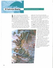
Env~ronmenat nd Resources Management I n January 1991, Chevron International (Yemen) graphic maps. The job fell to Chevron Overseas Limited concluded an agreement with the newly Petroleum Inc. (COP]), San Ramon, California and COP1 established Republic of Yemen for oil exploration and remote sensing supervisor James M. Ellis, with assis- production sharing in an area of Yemen known as the tance from Chevron Oil Field Research's remote sensing Shabwah Garden Block, an area characterized by rugged laboratory at La Habra, California. and varied terrain, including low relief desert, high The remote sensing team used imagery from the plateaus, towering cliffs and deeply incised drainage. NASA-developed Landsat Thematic Mapper (TM) and the To support field operations and logistics planning, French SPOT satellite, combining images from both into the company needed detailed geologic and topographic composite views to use the best capabilities of each sys- maps, but only small-scale base maps of the area were tem. Below is a TM/SPOT composite image of the available. Chevron therefore initiated a remote sensing Shabwah area typical of those used to extract a great deal project to develop a digital elevation model, and to gener- of information for support of field operations; the white, ate large scale images, improved base maps and topo- gray and light blue shades in the west (left in image) are areas of flat, sandy desert, dry river I courses and cobble/gravel surfaces, readily accessible to vehicles: red and qink signify limestone and shale areas; brown represents sandstone and green massive sandstone. The green area at bottom center is an area of steep to vertical canyons and cliffs that bar vehicular operations. The project was successfully con- cluded within the specified time of 11 months with delivery to the field of images, greatly improved base maps and unique topographic maps. COPI1sJ ames Ellis reported: "This project demon- strates that timely and practical application of remote sensing can support more efficient and cost-effective field operations."
