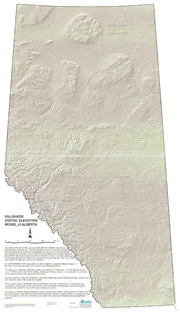
Hillshade digital elevation model of Alberta / compiled by Alberta Agriculture, Food and Rural Development, Resource Management and Irrigation Division. PDF
Preview Hillshade digital elevation model of Alberta / compiled by Alberta Agriculture, Food and Rural Development, Resource Management and Irrigation Division.
-HILLSHADE DIGITAL ELEVATION MODEL of ALBERTA The majority of the data for this map was constructed from elevation data licensed to Spatial Data Warehouse Ltd. The Forest Protection Division of Alberta Sustainable ~ Resource Development conducted the aggregation process (put the individual elevation files together into one big file). Data for areas of national interest such as Banff, Jasper and Wood Buffalo national parks were secured from Geomatics Canada. The Alberta Geological ¢ Survey aggregated both the national and the finalized provincial data sets. In all, some 3,200 map sheets (1:20,000) were used for this composite. For further information on the aggregation process(“mosaicing”), consult ER Mapper version 6.1 help files (“Introducing data fusion and mosaicing” and “Mosaicing DEMs’”). The resulting set of elevation points were spaced approximately 75 meters apart. In all, this data set contains some 170 million points, each with an easting, northing, and elevation value (x, y, z) coordinates. Construction of the combined data set was completed in May 2000. The data projection for this map compilation is the unified Alberta Ten Degree Transverse Mercator (10TM) using a North American Datum 1983 convention (NAD83). The composite image is “illuminated” using the ER Mapper version 6.1 sunshading tool. Sun shading was accomplished using a solar azimuth of 45 degrees and a sun elevation of 45 degrees. The final draping and compilation was carried out in an ESRI Arcview software environment. The continuous elevation data was acquired in order to develop computerized modeling efforts of the Soil Quality Monitoring program of the Alberta Environmentally Sustainable Agriculture Program (AESA). It has also been used as an input data source for the re-alignment of the Alberta Soil Landscapes of Canada ecological stratification polygons. cE; Compiled by: Albert Data provided by Alberta Sustainable Resource Development, 1 ) : AGRICULTURE, FOOD AND Spatial Data Warehouse Ltd., and Natural Resources Canada, RURAL DEVELOPMENT 3501 Geomatics Canada Resource Management and Irrigation Division
